 Commonwealth Consolidated Acts
 Commonwealth Consolidated Acts
(1) This is how a block is constituted in an offshore area:
(a) assume that there is laid over the offshore area a grid constituted by:
(i) lines running along meridians drawn through each degree of longitude and the minutes between those degrees; and
(ii) lines running along parallels drawn through each degree of latitude and the minutes between those degrees;
(b) take a bounded space defined by the grid;
(c) the seabed and subsoil within the offshore area that is under that space is a block in the offshore area.
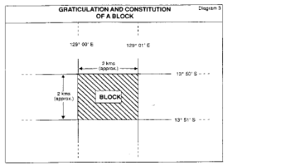
(2) The following diagram shows how a block is constituted:

Note: Each block is identified by giving the name of the plan in the 1:1,000,000 map series, an identifying number of the 5 minute primary block and a letter identifying the 1 minute block. The block in the diagram is 1621(a) on the Darwin sheet.